Table of Contents
開く- Introduction
- Birth of a civilization by paddy farming (Jomon (14,500BCE-300BCE)/Yayoi Period(300BCE-300CE))
- Development of small rivers by an ancient state (Kofun Period (300CE-538CE))
- Ritsuryo system and introduction of Buddhism and civil engineering technologies (Asuka(538-710CE)/Nara(710-794CE) Periods)
- Water management during the Shoen Period (8th cent. to 15th cent.) (after Heian Period)
- Manor control by a band of warriors (Kamakura Period(1185CE-1333CE) ~ Muromachi Period(1333CE-1573CE))
- Flood protection works by Sengoku Daimyo (Warring lord) (Sengoku Period(1467CE-1615CE) ~ Azuchi Momoyama(1574CE-1600CE) Period)
- New paddy field developments by regional characteristics (Early Edo Period (1603-1867))
- Achievements of Irrigation and Drainage Systems in the Modern Period (Late Edo Period (1603-1867))
- Water engineering techniques of the Netherlands and modernization of land improvement works (early Meiji Period (1868-1912))
- Shift to High-water River Works and Sophistication of Water Engineering Technology (late Meiji Period (1868-1912))
- River Developments by Constructing Modern Dams (Taisho period (1912-1926) ~ Showa period before the World War II (1926-1939))
- Development of present land improvement technology (Showa Period (1945-1989) after World War II)
- System renovation and measures against regional issues (Heisei period (1989-2019))
- Conclusion
1. Introduction
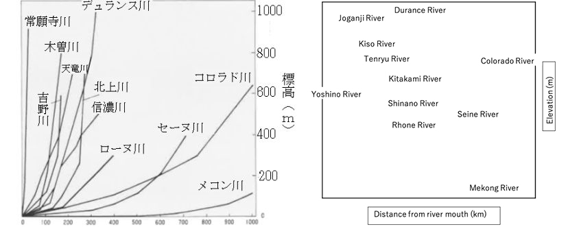
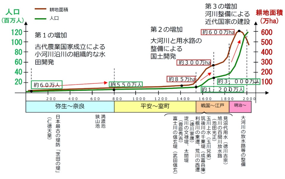
Japan is often cited as “a resource poor country”, but it is endowed with rich water resources, where the average rainfall is 1,718mm, nearly double the world average of 880mm1). However, rivers in Japan have steep slopes with short lengths compared to other rivers in the world (Figure 1), making flood control very difficult. A Netherlands’ engineer, De Leek, who was invited to Japan in the Meiji Period compared them to waterfalls, saying “This is not a river, but a waterfall”. As such, flood control has been difficult, and continuous struggles with river control have occurred throughout Japanese history, along with the development of paddy farming.
(Citation: Daichi eno Kokuin P58)
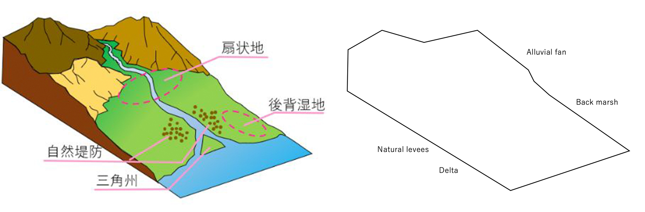
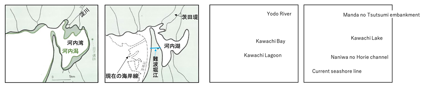
Seasonal fluctuations of rainfall are largely due to the effects of a monsoon climate. In the past, rivers with steep slopes flooded and carried large volumes of sediments, forming alluvial plains for people’s living (Figure 2). In coastal areas, a long-term natural sedimentation expanded the land area from bay to lagoon to lake (Figure 3). People living in these river-formed plains constructed and expanded irrigated cultivation land with their wisdom and hard labors, while experience the repeating process of community abolishment and rehabilitation by river flooding (Figure 4). People also enriched their livelihoods by utilizing water skillfully in such ways as hydropower by water wheel or water transport which have been major parts of logistics until the modern period.
(Citation: Daichi eno Kokuin P60)
(Left) Jomon period (5,000~2,000 years ago)
Kawachi bay became Kawachi lagoon by soil sedimentation
(Right) Yayoi ~ Kofun Period (1,800~1,600 years ago)
Sandbank enclosed the bay turning it into the freshwater Kawachi lake.
→Afterwards, the area became Osaka plain by artificial reclamation and other measures.
(Citation: ”History of river and human relationship” by Ministry of land, infrastructure and transport)
In this “Water Chapter”, we are going to focus on “water use technologies” that are the root of agricultural and rural engineering, review the history of water development that our ancestors have deeply engaged with from the birth of civilization to the present, and think about future prospects of agriculture and rural engineering.
2. Birth of a civilization by paddy farming (Jomon (14,500BCE-300BCE)/Yayoi Period(300BCE-300CE))
During the Jomon Period, when hunting and gathering had been the center of livelihood, people lived outside the river flooding inundation area. They lived in harmony with nature, collecting food by hunting, gathering, or fishing. People started to live around rivers only after paddy farming technology was imported into Japan. During the first half of the Yayoi Period, people started to obtain food by modifying nature and practicing farming, drastically changing their livelihood from that of the Jomon people. To construct and expand paddy farming areas, tools such as wooden plows and hoes had been utilized. However, the technology of modifying topography had not been fully developed, so paddy fields had been created in naturally formed semi-low land back marsh of alluvial plains and narrow flatlands at the bottom of valleys, and villages had been constructed on the semi-high land of natural levees adjacent to semi-low land. (Figure 2, Figure 2 in “Land Chapter”)
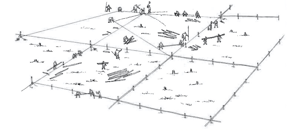
Paddy fields in the first half of the Yayoi Period had been formed by providing small modifications to natural marshy areas, however, with the population growth and the increase of labor capacity in the village, people started to improve the land. At Toro archeological site (late Yayoi Period, around 1st C. CE) in Shizuoka prefecture, more than 50 rectangular plots of paddy fields surrounded with bunds of piles and sheet piles were discovered in an area of about 10 ha, having a dual-purpose ditch for irrigation and drainage in the center. (Figure 5) After the late Yayoi Period, farm equipment with iron blades at the tip started to be adopted (Figure 4 in “Land Chapter”), and paddy fields had been expanded by developing irrigation systems in natural landscapes through organized collaborative works.
(Citation: Daichi eno Kokuin P24)
3. Development of small rivers by an ancient state (Kofun Period (300CE-538CE))
With the expansion of paddy farming, small villages were unified into a more powerful state (Kuni), and labors were controlled by a ruler which enabled the development of engineering technologies including water intake from weirs, construction of river embankments, and excavation of drainage canals by applying technologies of immigrants mainly from Korea.
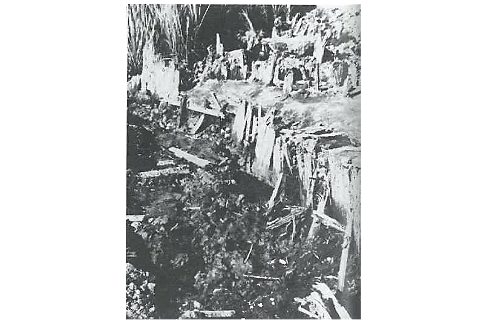
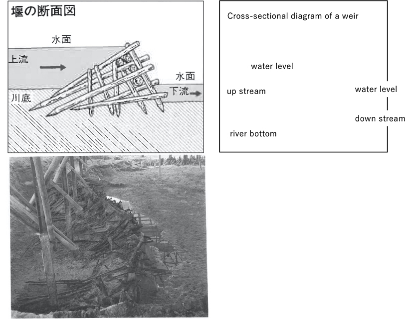
In the 4~5C. CE, a weir that could dam river water with a triangular wooden frame filled with clay and gravel was constructed, as typically shown in a weir (Figure 6) at Kodera archeological site (Ehime prefecture). Because such a simple weir could only endure the discharge of small rivers, a repeated process of destruction and reconstruction was continued during flood periods, when the area of paddy fields and rivers grew too big for the weir. When the production of paddy rice became stable, extra laborers could become mobilized in a centralized manner by the first unified state, the Yamato Imperial Court. Together with technologies transferred from the Asian mainland, numerous burial mounds (Kofun) were constructed from the 3rd century to the 6th century, mainly in the Kinki region (some theories mention a moat surrounding the Kofun could be utilized for water storage). Only pegs and ropes were available to survey and design the layout of Nintoku Daisenryo’s Kofun (Figure 7) that is about 460 thousand m2 (13 times as large as Tokyo Dome) (Figure 8). Experts propose that only human laborers with the simple equipment of iron spades/hoes and straw made hampers to carry soils were used to build the mound of 1.4 million m3, dig the double moats of 0.7 m3, and lay 5 million surfacing stones. This task would have taken 15 years and 8 months with 2 thousand laborers per day2). In addition to laborers, about 6 thousand people were deployed at the construction site to provide food and make equipment and clay images. Even with limited information transmission ability in this period, the administration of the time had a very high construction management capacity for controlling such large labor groups.
(Citation: Daichi eno Kokuin P116)
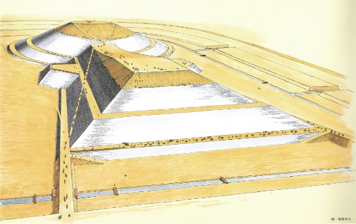
(reproduced by Obayashi Gumi Co. Ltd., drawn by Kazuo Hozumi)
4. Ritsuryo system and introduction of Buddhism and civil engineering technologies (Asuka(538-710CE)/Nara(710-794CE) Periods)
During the Asuka Period, the Ritsuryou based central control state was gradually established after the Taika reform (645). This was accomplished by adopting the advanced culture and system of Tang, China, which evolved from a clan based society dominated by clans who exerted local control. Adoption of the Kouchi Komin system (a system of state-owned land and people) and the Handen Shuju (rice field allotment) law showed that rice itself was the financial base for the Yamato Imperial Court. Thus extension of paddy fields and securing irrigation water became the absolute conditions for continuing the Imperial State and maintaining the Ritsuryou system. In the 7th century, large keyhole-shaped tomb mounds suddenly disappeared and high ranking priests who learned Buddhism and civil engineering technologies from the Asian mainland started to extend the construction of irrigation reservoirs using a valley-based model. Creating an irrigation reservoir by enclosing the mouth of a valley is more efficient because it decreases the soil volume moved for banking and digging compared to a dig-in type reservoir. This method can lead to large flood damage once the embankment is breached, so it required advanced civil engineering technologies. Sayama Ike reservoir (the oldest reservoir described both in the Kojiki and the Nippon Shoki), which is said to have been constructed by a priest, Gyoki, was confirmed to be constructed in 616 (early 7th century) by a dendrochronological method at the time of modernizing a wooden sluice (modernization completed in 2001).
Manno Ike reservoir (Kagawa prefecture, Figure 9), rehabilitated by a priest, Kukai, in 821, was breached in 1184. It was rehabilitated after about 450 years, however, breached again by the Big Ansei Earthquake in 1854, it had to be restored. After raising the height of the embankment three times in 1905, 1927 and 1941, the reservoir’s present capacity of 15.4 million m3 was reached in 1959. Even with repeated breaching and rehabilitation of reservoirs, about 167 thousand irrigation reservoirs have been identified as of 2019, and about 70 percent were deemed to be constructed during the Edo Period or before.
(Right) A photo of reservoir rehabilitation (Citation: Daichi eno Kokuin P126, P163)
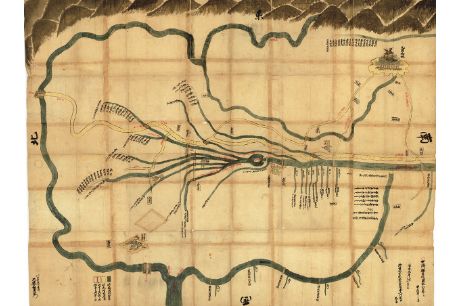
In 646, the imperial court issued an order that said “construct the embankments in rivers for land development,” and flood protection works were implemented with the forced labor of farmers. The Yamato basin had been the center of culture and politics and an important traffic point that connected the Kyoto basin with the Kizu river, and the Kii plain with the Yamatogawa and Kinokawa rivers, Namba, and the Seto Inland Sea. In the middle of the Nara Period, small river channels were improved in line with the chessboard layout of land allotment prescribed by the Jori system. Channels were used for both irrigation water and ship transportation (Figure 10).
(source: Modified part of a diagram in “Development of ancient basin and river management3)” by Shigeki Matsuura)
5. Water management during the Shoen Period (8th cent. to 15th cent.) (after Heian Period)
During the early period after the enactment of the Konden Einen Shizai Law(a law allowing farmers/developers to own cleared land permanently) in 743, manors were mainly “self-developed” which meant they were developed and managed directly by temples/shrines, aristocracy, and local lords. However, around the 10th century, the “donated manor” became mainstream, which was a self-developed manor donated by local lords to aristocrats and temples/shrines to avoid the pressure of the central government. The local lords instead became managers of the manor and seized the real power. As the area of manors increased, large scale development by the central government became difficult, and some people argue that little progress was achieved during the Heian Period.
The size of a manor was usually about 50 chobu (around 50 ha.) and relied on small rivers or reservoirs for irrigation. However, due to the neglect of proper maintenance and repair, the area of Kataarashi (poorly cultivated) paddy fields increased. For example, Todaiji temple owned 3,462 ha of paddy fields nationwide in 950, however, only 212 ha. (6%) was actually cultivated4).
For more than one thousand years, from 794 to when the Heian Capital (Kyoto) was moved during the Meiji Period, major commercial and physical distribution was supported by water transportation for the capital of Japan, Kyoto. The Yodogawa River is a large river with an abundant and stable flow due to the regulating functions of Lake Biwa. It became a major distribution path connecting Kyoto with the coastal areas of the Seto Inland Sea where salt production sites, forest areas, and farmlands existed. The Kamogawa River, which belongs to the same Yodogawa River system, does not go through Lake Biwa and often overflowed its banks. Emperor Shirakawa (1053-1129) called it one of three issues that he could not control on earth, or Tenka Sandai Funyoi (the remaining two issues were a roll of the dice and priest soldiers of Mount Hiei).
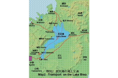
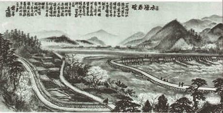
It is about 20km in a straight line from the northern tip of Biwa Lake to the Sea of Japan, and on the eastern side of the lake, major roads went to the eastern part of Japan, thus water transportation in Lake Biwa played a major role in connecting Kyoto with the Sea of Japan and the eastern part of Japan (Figure 11). In particular, Japan’s front gate for envoys from the continent was the Hokuriku region, where abundant rivers with snow melt flow were stable for paddy cultivation and water transport. In this region, many manors were developed and rice was the annual tax. Fishery products and specialty goods, including lacquer ware, were brought to Kyoto by water transportation, and supported the native Japanese culture which bloomed during the Heian Period (until the modern period, the side of the Sea of Japan was known as the “front side of Japan”.)The Juugo irrigation canal system (Fukui prefecture, Figure 12), constructed in 1110 (Tenei Gannen), irrigated the 600 ha. manor owned by Kofukuji Temple and was one of the largest irrigation systems of the time. According to a legend, a weir was constructed at the site (Naruka at present) where a deer cried three times along the Kuzuryu River and a canal of 28 km was excavated along the path where the deer went by the revelation of the Kasuga Myojin deity.
(Citatoin: Webpage of the Imperial Household Agency)
(Provided by Fukui prefecture in ”History of Fukui prefecture by illustration”)
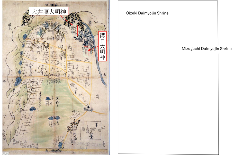
Weirs and canals safeguarded manors by providing irrigation water and maintaining paddy fields, so a God of Water was enshrined in the manor’s shrine indicating that they were the very important to the manor. Shrines such as Oizeki Daimyojin Shrine and Mizoguchi Daimyojin Shrine, shown in the map of Izuminokuni Hinenosho (Hineno manor in Izumi province) (Osaka prefecture) in Figure 13, that had canal paths in the shrine property were worshipped by users of weirs and canals and those who engaged in construction works. They became a symbol to unite local groups through such events as festivals, ritual performances praying for a good rice harvest, and rice planting Shinto rituals.
(Provided by the Archives and Musolea Department of the Imperial Household agency)
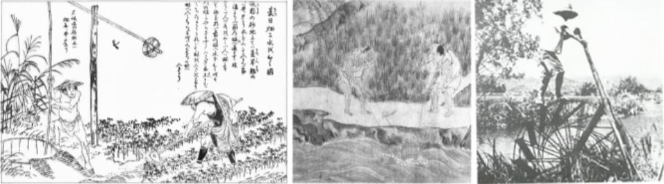
Use of water wheels started during the Heian Period5). Sophisticated technology adopted for a wheel in the Ujigawa River was recorded in the Kamakura Period work “Tsurezure Gusa” (Essays in Idleness). Water wheels along Ogura Ike (Ogura pond), near the Ujigawa River, amounted to more than 100. Around the 16th century poems about the natural scenery of rivers were often illustrated in books of famous places. Pumping apparatuses (Figure 14) such as hanetsurube or nagetsurube, well buckets and treadmills respectively, continued to be used in many local areas even after the Edo Period. Until fossil fuel energy became available people had to invest a large amount of labor for pumping water. The Jyuren Suisha Gun (multiple water wheel group) in Fukuoka prefecture’s Asakura Town (Figure 15) is the oldest water wheel in Japan, constructed about 230 years ago in 1789, and is still operating. It is renovated every 5 years by local artisans to continue the traditional techniques into the present6). Operational, maintenance and design techniques used for Asakura Jyuren Suisha Gun and the Yamada weir (a sloped stone faced weir) are applicable to developing countries. The late Doctor Tetsu Nakamura transferred these techniques to Afghanistan, which has saved lives beyond time and space7) by enriching the land of a foreign country.
(Citation: Daichi eno Kokuin p.121, p123)
(Left) Hanetsurube (Swing well bucket) : often used to pump water from a well for cotton produced in the Kinki region.
(Middle) Nagetsurube (Throw well bucket) : used for emergency during drought
(Right) Treadmill: used numerously in creek regions in Saga plain.
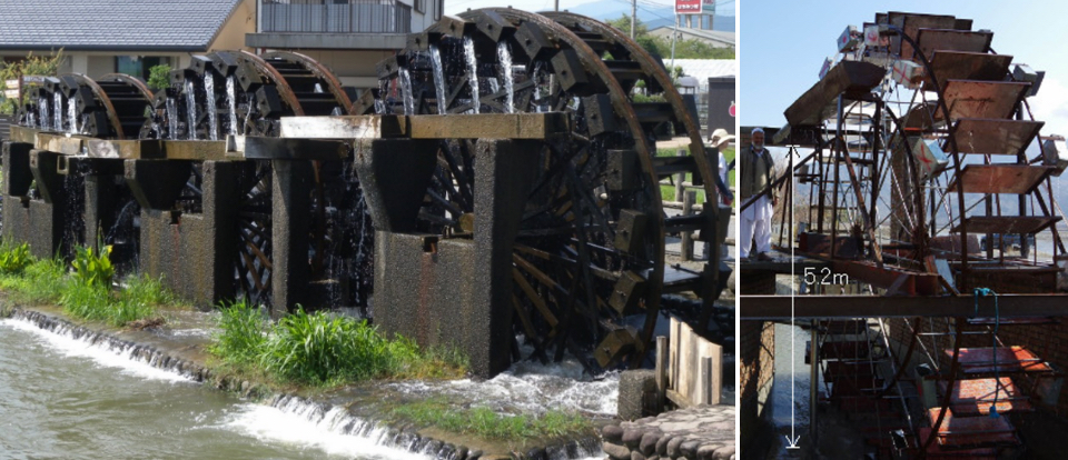
(Left) ”Triple layered water wheel in Asakura” originally constructed before 1789 (source:Kyushu Regional Agricultural Administration Office, MAFF)
(Right) Water wheel in Marwarid Canal modeled after Asakura water wheel , which irrigates 40 ha with pumping of 1,200 ton/day. (Citation: Homepage of Peshawar-Kai (a report from Dr. Nakamura on 2014.2.6))
6. Manor control by a band of warriors (Kamakura Period(1185CE-1333CE) ~ Muromachi Period(1333CE-1573CE))
When privileges of Fuyu no Ken (the right of tax exemption) for a manager of the manor gradually expanded to Funyu no Ken (the right of denying the entrance of tax agents into the property), managers started to strengthen self-defense capacity and use warriors to assure the control of their property without relying on Kenmonseika (powerful temples/shrines and aristocrats). Yoritomo Minamoto turned local landlords in the Kanto Region into Gokenin(vassals) and strengthened the control of manors by appointing them as Shugo, provincial constables, of each province and Jito, territorial stewards, for each manor or public territory. The right of establishing and appointing Shugo or Jito by Yoritomo was authorized by Imperial sanction (Bunji no Chokkyo) in 1185, when the Kamakura Period started.
The Kamakura Shogunate owned territories in the Kanto and Tohoku regions where uncultivated land widely extended, and promoted the development of the Kanto Plain, focusing on Musashi Province. The development of flood-prone areas on the Kanto Plain was not possible with the prevailing technology level of the time. Large scale flood protection and reclamation works had been carried out there since the Ritsuryo Period, but was limited to the mountainous western part.
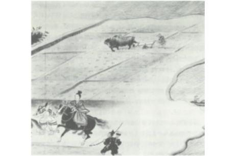
During the Kamakura Period, double cropping, and the use of oxen/horses with animal-power equipment were widely applied (Figure 16). Jito in local areas followed the practice of the Shogunate to implement small scale development works including river branches/mountain stream flood protection and irrigation canal development. Warrior groups established bases of operations in lands around the middle of the Kisogawa, Tenryu gawa, Fujigawa, and Shinanogawa rivers. Warriors flourished during the Muromachi Period, such as Nitta, Ashikaga, Hatakeyama, Hosokawa, Isshiki and Imagawa who were former Jitos who expanded their territory by such developments.
(Citation: “Story of Paddy Fields” P81)
During the Muromachi Period, Shugo took over the authority of provincial lords of the manor and acquired the authority for controlling land and people as Shugo Daimyo (Japanese territorial lord as provincial constable). Small and medium farmers who were forced to work like slaves for manor lords improved their power and position with the weakening authority of their lords. This led to the formation of a rural local self-government called So, made up of naturally formed, regionally grouped settlements as a unit. The capacity of farmers for self-reliance was enhanced through community based collaborative management of irrigation water. For example, the Imai Irrigation System in the Katsuragawa River in Kyoto, was managed not by the lord, but by a farmer leader of the village, who formed the contract of irrigation water use among three villages (1338-1342)4) Furthermore, mountain forests and wastelands that were used as the sources for double cropping fertilizer were incorporated into the Iriaichi (common land), which was collaboratively managed by farmers. Through collaborative management of common land and irrigation systems, the solidarity of So was strengthened. At the end of the Muromachi Period and during the Sengoku Period, farmers started to resist their Jito, or local lords, by military force in order to initiate Peasant/Ikko uprising when their livelihood was threatened illegally.
7. Flood protection works by Sengoku Daimyo (Warring lord) (Sengoku Period(1467CE-1615CE) ~ Azuchi Momoyama(1574CE-1600CE) Period)
During the Muromachi Period, Shugo Daimyo (territorial lords as provincial constable) were appointed by the Muromachi Shogunate as rulers of the provinces. However, when the Shogunate lost its power and control over Daimyo in 1467, after the Onin War, Sengoku Daimyos (territorial lords during Sengoku Period) emerged regardless of their birth or origin, by overthrowing their lords, controlling the land and farmers of their territory, and competing to expand their territory to other provinces. Following the proverb of Chinese Spring/Autumn and the Warring State Period; “those who govern the state well control water at first.” Sengoku Daimyos integrated flood control works with developing new lands, by leading subordinate warriors to increase rice production and enhance national wealth. With the development of civil engineering technology through castle building and mine development, inundating areas which had been left uncultivated were developed by embankment and irrigation canal building.
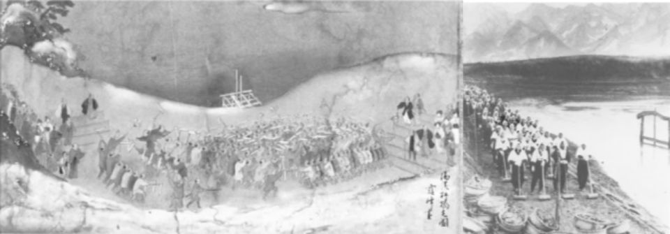
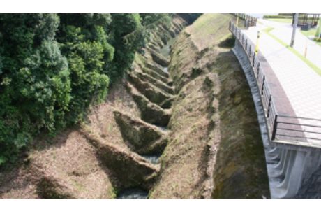
The Koufu Basin, where Shingen Takeda was based, was flooded every time severe rain fell by rivers coming from all directions that changed their routes when pouring down the alluvial fan. The flood of Kamanashigawa River in 1542 prompted Shingen to encourage flood protection measures by adopting the Koshu School of flood protection (Koshuryuu Boukahou). As shown in Figure 17, the flow of the steep sloped Midaigawa River flowing from the west side of the Kofu basin was fixed and controlled by the Kasumitei levee (Intermittent levee). The levee was also called Shingen Zutsumi (G), after dissipating the flow of energy by a Shogi (Japanese chess) piece shaped embankment called “Shogi Gashira” (B and C), absorbing energy by hitting the rock cliff “Takaiwa” (F) at the merging point with Kamanashi River, and further reducing the water force by wooden frames filled with boulders and stones or “Hijiri Ushi (Figure 17). After succeeding in controlling the river and reducing the flood damages, new paddy fields were developed in formerly inundated areas. People in the domain living close to Shingen Zutsumi were encouraged to migrate by tax exemption and labor contributions. People in the domain were also mandated to engage in flood protection works to establish a system of disaster management during flood periods. Shingen also encouraged people to participate in the “Omiyuki Festival”(commonly called as Omiyukisan), which was held before flooding periods to pray for safety against floods. This festival also functioned to compact the embankment when many beneficiaries stepped and carried a heavy portable shrine, which in the end became a custom of operation and maintenance8) (Figure 18).
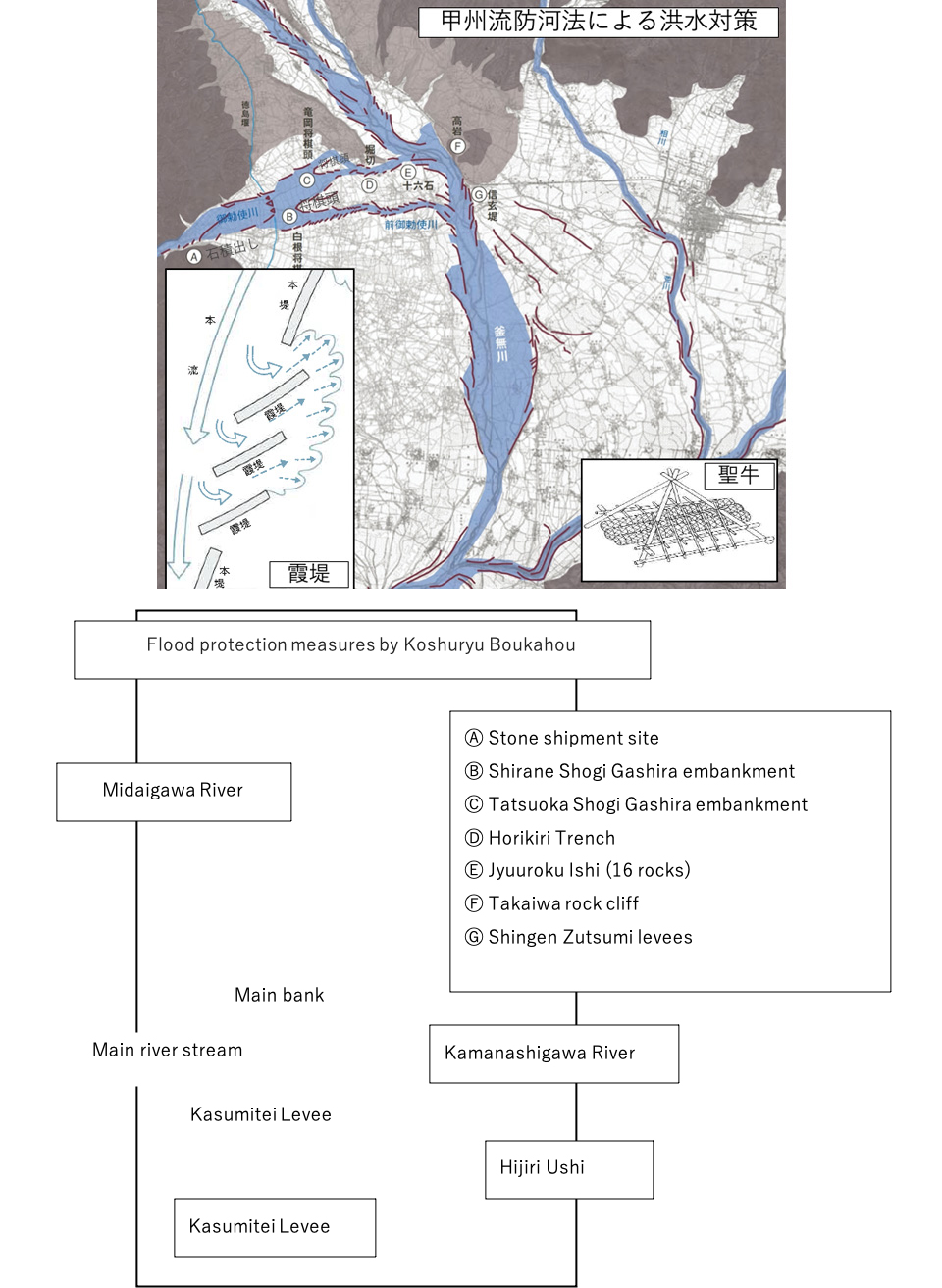
Kasumitei are intermittent levees that allowed overflowing at the time of flood to avoid breeching without disturbing the flow direction, and after flooding ended overflown water upstream could naturally return back to the river.
(Citations: Mitsukan Water Culture Center, and “Daichi eno Kokuin”, p.136 and p.139)
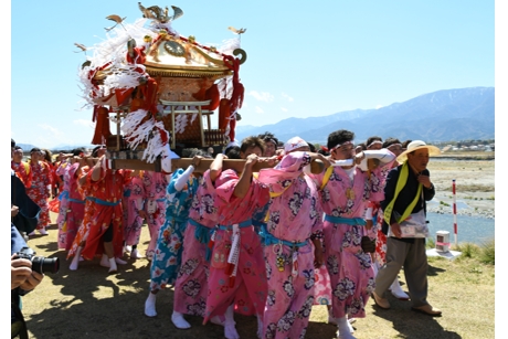
-This festival is still held every year on 15th of April-
Experts consider that Shingen obtained advice about water engineering techniques from flood control facilities at Tokou En (Dujiangyan Headworks) in the Chengdu Basin in Sichuan Province, China. In 1583, Narimasa Sasa also made distinguished achievements in flood control by constructing the Sassa Tei (Sassa embankment) and the Tonosama Bayashi (flood prevention forest) in the Joganjigawa River in Toyama prefecture. Techniques applied to his flood control works are quite similar to Shingen’s and seem to have been learnt and provided by Shingen’s engineers after the Battle of Nagashino in 15759).Kaneyoshi Ooki who supported the Narimasa’s flood control works as a subordinate warrior, was later employed by Kiyomasa Kato as a river engineering administrator after the seppuku (suicide by disembowelment) of Narimasa. He supported Kiyomasa, who became a feudal lord of Higo(Kumamoto prefecture) in 1588, through river management and new paddy field development works. Shingen’s techniques were mainly applied to an alluvial fan in the middle and upper streams of the river, while those of Kiyomasa were applied to a plain in the middle and lower part of the river to develop new paddy fields and implement land reclamation. The Hanaguri Ide(desilting canal) in Figure 19 was also created for this cause. While the roots of Kiyomasa’s techniques were similar to Shingen’s, his were improved according to the conditions of local areas. Hyougo Naritomi, who suffered from the dispatch of troops to Korea together with Kiyomasa, learned the techniques of Kiyomasa and later applied them to develop the Saga Plain (an extremely flat land with an average gradient of one over ten thousand, a big tidal range of more than 5m on average, etc.). He controlled the natural conditions of Saga Plain through the integration of wide water use systems by creating flood control, irrigation and drainage by connecting small and medium rivers, old creeks, inlets, and lakes skillfully. During the Sengoku Period, river engineers migrated together with feudal lords and transmitted techniques, which contributed to the development of civil engineering technology suited to regional characteristics.
Lower part of a partition wall of bedrock has a hole like cattle nose ring, which prompts spiral water flow and prevents silting of Aso Mountain volcanic ashes at the bottom of a canal.
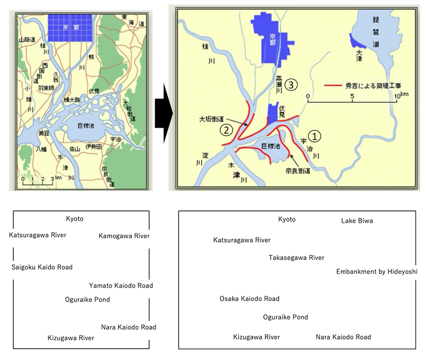
After Hideyoshi Toyotomi unified the country by ending war, he constructed Fushimi Jyo Castle in Kyoto in 1594 and the Taiko Zutsumi (embankment) in the Kizugawa River. He improved the water transportation system of the Yodogawa River and transferred the flow of the Ujigawa River northward to separate it from Oguraike Pond (Figure 20), prevent floods, and expand cultivation areas. He also confiscated weapons from farmers by Katanagari(sword hunts), prohibited the change of social positions (separation of warriors and farmers), and ended the act of Gekokujyo (overthrowing one’s lord). Taiko Kenchi (cadastral surveys) were carried out to determine feudal tenure all over Japan, which established the foundation for the centralized feudal control of the following Edo Period.
(Citation: Suidono Ishizue in Yodogawa Suikeishi (Yodogawa Basin History) Chapter 6 by ARIC)
8. New paddy field developments by regional characteristics (Early Edo Period (1603-1867))
Sengoku Daimyos (warlords) before the Edo Period could expand their rice production capacity (Koku), which was the financial foundation of their territory by invading other provinces. However, during the Edo Period feudal lords could not expand their territory, and thus engaged in developing inundation areas, such as alluvial plains and deltas, which encouraged using water engineering techniques according to regional characteristics.In the Osaka Plain and the Kinai Basin, old water engineering techniques called Kamigata Ryuu (Kamigata School) progressed and were applied to Iruka Pond in the Nobi Plain in 1633 and the Wakasa Tei embankment in 1636.
Techniques to construct enclosing dikes (Wajyu Tei) (Figure 21) in the Kiso Sansen (Kisogawa, Nagaragawa, Ibigawa) basin area of the Tokai region are of the Mino School. Enclosing dikes were constructed to avoid flood and inundation in Mino province as a means of self-defense. When Ieyasu Tokugawa (the first Shogun of Edo Shogunate) ordered construction of Okakoi Tsutsumi in 1608, he said the “embankment of the Mino Domain side should be 3 jaku lower (about 90 cm) than the one of Owari Domain side”, to protect the area of Owari Domain, the territory of Tokugawa Gosanke (three privileged Tokugawa branch families). After the heavy flood event in 1753, the Tokugawa Shogunate ordered Satsuma Domain to construct Aburashima Shimekiri Tutsumi (closing dike) and other dikes. 947 Satsuma retainers were dispatched to Mino Domain for construction work. A large sum of the construction cost was borne by Satsuma Domain and many victims were sacrificed; 51 died of suicide by disembowelment for protesting the unjust work, 33 died of illness, and a chief retainer, Yukie Hirata,killed himself by his own sword after the work was completed (Horeki Flood Control Work).
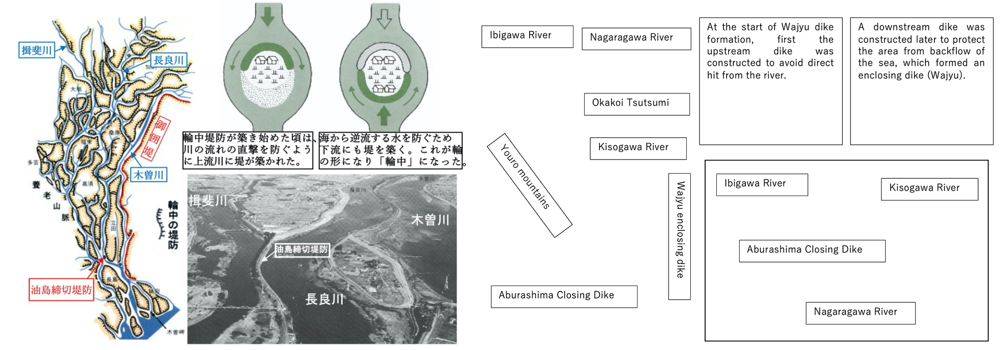
(Left) Mikakoi Tei and Wajyu Tsutsumi in Kiso Sansen (Before the rehabilitation of Meiji Period)
(Up right) Start of Wajyu (Diagram)
(Down right) Wajyu areas where three rivers of Kiso, Nagara, and Ibi merge.
(Citation: Website of Nagara Estuary Weir Management Office, Daichi eno Kokuin p.96)
In the Sendai Plain, Jyuukichi Kawamura, a Christian, developed a large low marsh area of the Kitakamigawa, Sakogawa, and Eaigawa River basin, by merging three rivers (1616-1626) and established a network of water transport. Development works applying western technology introduced with Christianity can also be observed in such constructions as the Jyuanzeki Weir, constructed by Jyuan Goto by applying a siphon technique in 1618.
The Kanto Plain was a large, inundated area, where rivers, lakes, and marshes repeatedly joined and flows split in all directions. The Shogunate adopted the Kanto School (also called Ina School) which followed the Koshu School(Figure 17) to develop uncultivated parts of the Kanto Plain into a huge granary. This was achieved by gradually shifting the path of the Tonegawa River, that originally flowed into Tokyo Bay, to the east and making it flow into the Pacific Ocean (Eastward translocation of Tonegawa River (1594-1654) in (Figure 22). A feature of the Kanto School was a flood water retention approach to a meandering river that “meanders 48 times every 4 kilometers.” This school constructed Kasumitei levees to overflow flood water to neighboring wastelands and protected paddy fields with Hikae Tsutsumi levees. Another feature of the Kanto School was in its use of old river courses. Chyuji Ina constructed Minuma Tamei irrigation pond in 1629 by building the Hatcho Tei embankment (length of Hatcho: about 870m) along an old river course in Minuma (Saitama City). In the Kasai Yousui Irrigation Project (1660), a dead water section of the old Tonegawa River, caused by translocation, was utilized for an irrigation/drainage canal, and three irrigation ponds were added to turn vast neighboring low marshy land into paddy fields. The Kanto School was adopted as an official civil engineering technology of the Shogunate, and was widely spread in Japan by local administrators dispatched all over Japan.
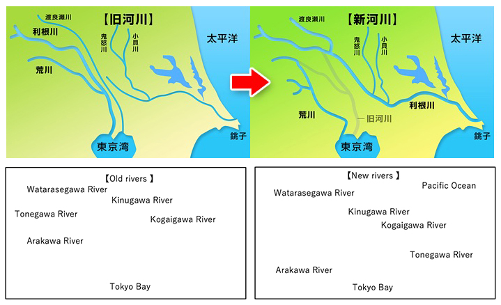
(Left) Old Tonegawa River course
(Right) New Tonegawa River course
By translocating the Tonegawa River eastwards, not only flood control in a huge, inundated area of Kanto Plain could be realized, but also a stable water transport system from Edo (Tokyo) to the Tohoku region was established. (Citation: Webpage of Minuma Tanbo)
The shogunate and local domains encouraged the private sector to initiate new land development in the form of Murauke Shinden (Village contracted new paddy field development) and Choninuke Shinden (merchant contracted new paddy field development) by tax exemption/reduction and other measures. A typical project under these shinden is the Gorobei Yousui irrigation system (1626-1631) in Nagano Prefecture which Gorobei Ichikawa, who was once a samurai warrior, undertook in collaboration with numerous farmers and mine workers. Another typical project is the Fukara Yousui irrigation system (1668-1672), initiated by the Fukara Mura village head, Gennojyo Ooba, and others in Shizuoka Prefecture, which developed paddy fields of several thousand ha. by digging a 1,200 m tunnel of hard rock in the Hakone volcanic zone. One more typical project is the Kounoike Shinden project (1705) initiated by a wealthy merchant family, the Kounoike in Osaka prefecture, which developed new paddy fields of 120 ha. by translocating the flow of the Yamatogawa River, which once flowed into the Yodogawa River and the ocean.
In 1609, the Population of Edo (the center of Edo Shogunate) was about 150 thousand, and securing drinking water was an important task, because the use of underground water was not easy due to Edo’s solid ground. Fujigoro Ookubo constructed the Koishikawa Jyosui water supply system in 1590, which was later extended to complete the Kanda Jyosui water supply system in 1629. At the time of the third Shogun, Iemitsu Tokugawa, the population of Edo rapidly increased with the establishment of the Sankin Koutai Seido (a system of alternate-year residence in Edo by Daimyo lords) to force Daimyo lords, their family members and retainers to reside in Edo. In 1654, the Tamagawa Jyosui water supply system, which withdrew water from the Tamagawa River, was completed to supply abundant water to the people of Edo. The system diverted its water along the Musashino Daichi plateau, and significantly contributed to developing new paddy fields on the plateau where water was scarce.
New paddy field development progressed rapidly based on the adaptation of water engineering technology to individual local features. During the first hundred years of the Edo Period a total cultivation area of about 1.5 million ha. at the beginning doubled in size to about 3 million ha.
9. Achievements of Irrigation and Drainage Systems in the Modern Period (Late Edo Period (1603-1867))
In the early 18th century, the population of Edo increased to over 1 million. After serving as lord of Kishu Domain, Yoshimune Tokugawa became the 8th Shogun in 1716, and posted an official bulletin board on Nippon Bashi in Edo to encourage new paddy field development in 1722. To initiate further development of the vast Kanto Plain as one part of the Kyoho Reform, he invited Yasobei Tamenaga Isawa from Kishu (Wakayama Prefecture) in 1723 to become a government official of the Shogunate. Yasobei’s civil engineering techniques, known as the Kishuryu School, were applied in place of the Kantoryu School and were acquired from Saizo Oohata, who followed the Kamigataryu School.
The Kishuryu school abolished Kasumitei School levees adopted by the Kantoryu School and straightened meandering river courses with firm continuous levees and water regulating works, including dredging and bank protection. New paddy fields of 15,000 ha. were developed through various methods, such as reclaiming Minuma Tamei pond and marsh lands along the canal, by destroying the Hatcho Tei embankment, and separating irrigation and drainage, respectively. Another developmental method was alternative irrigation of water from the Tonegawa River through the newly constructed 60 km. long Minuma Dai Irrigation Canal (Figure 7 in Land Chapter). In the present, the Minuma Dai Irrigation Canal supplies domestic water (drinking water) to the Tokyo metropolitan area through the Musashi Canal, developed in 1965. Water transport was very popular during the Edo Period, however, water levels were too low for ship use in the downstream reaches of the Minumadai Irrigation Canal after most of the water was withdrawn for irrigation, while the flow in drainage canals increased as it went downstream. To utilize canal networks for water transport, Minuma Tuusen Bori (Figure 23), a navigation lock, was constructed in 1731 (183 years before the completion of the Panama Canal) to connect the downstream irrigation canal with the drainage canal. Their water level difference was 3m.
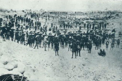
Through the Minuma Tuusenbori lock, many materials such as rice, vegetables, and wood were transported from the Minuma paddy fields area to major consuming areas of Edo. On the return from Edo to Minuma , ships transported manure (human waste) for use as fertilizer in the paddy fields. As such, Japan established an extensive system of material recycling involving the buying and selling of waste materials, which impressed foreign visitors with the clean sanitation conditions in urban areas. In Western countries at this time, wastes were discarded on the streets as populations grew in urban areas (Figure 24), resulting in deterioration of sanitary conditions, outbreaks of plague, and becoming a serious social problem10).
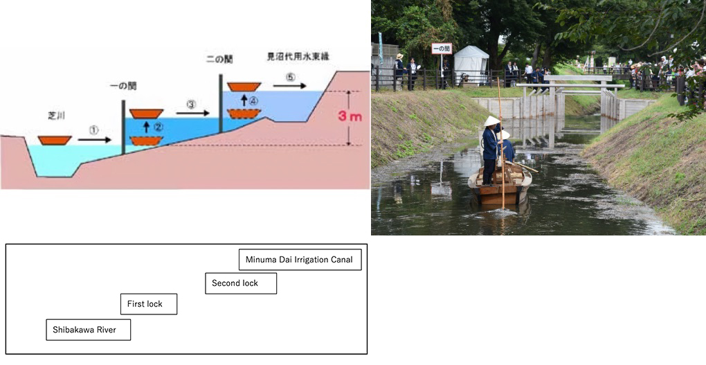
(Citation: (left) Webpage of Minuma Tanbo, (right) Saitama City Education Board)
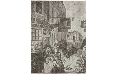
William Hogarth (1738)
(Citation: Daichi eno Kokuin p.75)
In 1854, Tuujun Kyo aqueduct, (Figure 25) based on arch principles, was constructed to deliver water to the water scarce Shiroito Plateau (Kumamoto Prefecture). Sou Shouya (a leader of village headmen) Yasunosuke Fuda , used unique planning and design in collaboration with a masonry group, financial support from Higo Domain, and the participation of neighboring farmers. The aqueduct made use of the technology of the time, including firm masonry techniques, an inverted siphon waterway, and a sedimentation discharge outlet on the aqueduct.
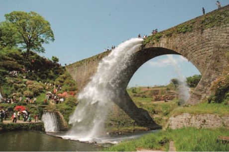
(Citation: Website of MAFF)
10. Water engineering techniques of the Netherlands and modernization of land improvement works (early Meiji Period (1868-1912))
At the end of Edo Period, about 1.87 million warrior class people received about 13 million Koku (1 Koku is about 150kg of rice) of salary, but it was reduced to 4.92 million Koku (less than 40%) by the Rokusei Kaikaku (salary system reform) of the Hanseki Houkan (the return of lands and people to the Emperor) in 1869. Furthermore, in 1872 a conscription ordinance announced the introduction of a universal conscription system, making professional warriors unnecessary. The Meiji government promoted reclamation projects to create jobs for ex-warriors (Shizoku Jusan). Impoverishment of ex-warriors, particularly those of the lower class, led to the breakout of the Seinan Senso War in 1877.
The Meiji government, after the dispatch of the Iwakura Mission (1871-1873) to observe and inspect conditions of western countries, adopted a policy to promote new industries (Shokusan Kogyo) under the slogan of “Fukoku Kyouhei”, enriching the country and strengthening the military, by introducing modern science and technology. Many water engineers from the Netherlands were employed by the Meiji government, including Von Doorn and Johannis de Rijke (Figure 26).
In implementing the Asaka Sosui Irrigation Project in 1879 (Figure 10 of Land Chapter), irrigation water requirements were calculated for the first time in Japan by the guidance of Von Doorn. Western technologies and materials were applied in the construction such as a large volume of cement for strengthening weir banks, tunnels, canal bottoms or other structures, dynamite and electric blasting, and steam pumps for drainage of excavating tunnels for agriculture purposes. The project opened a new era of applying and spreading modern western technologies in agricultural and rural engineering works across Japan. Ichirobei Minami, born a son of a village leader in Usa (Oita Prefecture), was appointed as an engineer of the Ministry of Internal Affairs. He was engaged in the entire process of the Asaka Sosui project, after being recognized for his technological capacity implementing the Hirose Ide Irrigation Canal Project (started in 1869 as the first national irrigation project) by Masayoshi Matsukata. Ide was appointed chief supervisor of the Nasu Sosui Irrigation Project in 1885, conducted a survey for the Lake Biwa Irrigation Project (1885 ~ 1890) and submitted an opinion document on water use. His actions left footprints and he became known as a father of Japan’s three biggest irrigation projects11).
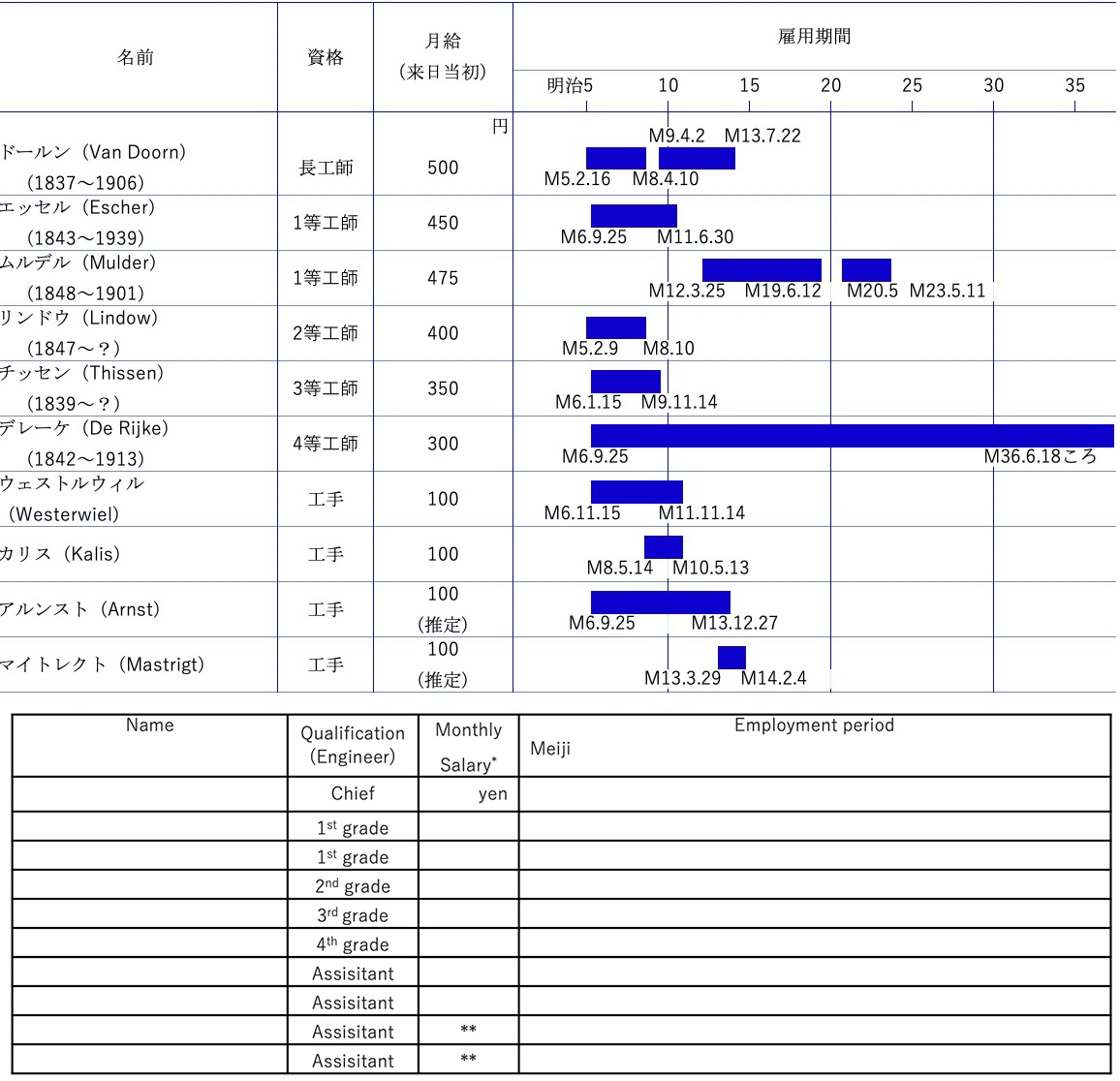
(source: Partly modified the figure in p79 of “Nippon No Suisei” by Kouichi Yamamoto) * Salary at the beginning of arrival to Japan, ** Estimate
The Meiji Yousui Irrigation Project (Figure 27)was initially planned by Yakou Tsuzuki of Anjyo city at his own expense for developing new paddy fields. His plan was submitted to the Edo Shogunate’s commissioner of finance in 1827. This plan was supported by the Shogunate, but local support was not obtained due to complex conflicts of interests. The Tsuzuki family went broke by contributing 25 thousand ryou (currency unit of Edo Period, 1 Ryou =40~400 thousand yen at current price, on average 1 ryo= 13 thousand yen.) to the project. Forty years after the death of Yakou in 1873, Hamamatsu Okamoto, a merchant, and Yohachirou Iyoda, a wealthy village head, separately submitted similar irrigation project plans to Aichi Prefecture, which Aichi Prefecture merged into one and then invited investors to raise funding. The project started in 1879, and its main canals were completed in 1881. Masayoshi Matsukata named this project “Meiji Yousui”, because it was completed through private financing and a representative project of the Meiji Period. Extensively irrigated beneficiary areas became advanced regions of farming in Japan and sometimes called Japanese Denmark.
(Citation: Daichi eno Kokuin p.104)
Water engineering technology of the Netherlands was based on the principle of securing flow capacity by excavating a river channel and using low-water river works to stabilize the flow with water regulating facilities in channels. With the guidance of Netherlands engineers, such works as the Kiso Sansen Bunryu project (1887~1912) were implemented. Water engineering technology of the Netherlands had long been the model of modern flood control works.
With the progress of river improvement works, Goukuchi (unification of head works) was implemented. Traditionally, severe upstream‐downstream confrontations based on customary water use practices occurred. In the Jyoganjigawa River in Toyama Prefecture (Figure 28), after a devastating flood in 1891, the first large scale unification of head works based on a rehabilitation plan by de Rijke was implemented. After this project, unification of head works along with the implementation of river improvement work became popular in Japan, such as the Shichika Irrigation Canal Project in 1903 in Ishikawa Prefecture (Figure 29) and the Tozai Yosui Irrigation Project in 1907 in Okayama Prefecture.
(Supplied by Midori Net Jyousai Yousui)
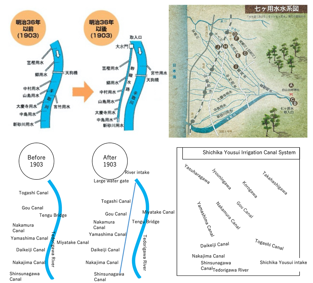
(Citations: (Left) Website of Tedorigawa Shichika Yousui Tochi Kairyouku, (Right) Notthi Newspaper, Vol.7, Dec. 2007)
11. Shift to High-water River Works and Sophistication of Water Engineering Technology (late Meiji Period (1868-1912))
In the middle of the Meiji Period, flood damage control using only low- water river works introduced from the Netherlands became difficult. Thus, the flood control system made a major shift to high-water river works that linearized river channels, used high continuous embankments and led river flow to the sea through discharge channels. Such major shifting of river work systems was caused by: deforestation for railway constructions between Tokyo and Kansai in 1889 and between Ueno and Aomori in 1891, associated construction booms, series of devastating floods in prospering downstream areas, and lowering needs of water transport for low water control by railway construction.
In 1896 River Act (old act) was enacted and an integrated method of calculating designed river flow by river engineering based on modern western science came to be put into practice. As such, large scale flood control works, such as the Yodogawa River Improvement Project (1897 – 1910) and the Ookouzu Bunsui Diversion Project (1909 – 1922), were carried out, and water use systems focused more on flood control rather than the Edo Period’s focus on agriculture. During this period, Hidesaburo Ueno opened a course in agricultural and rural engineering at Tokyo University in 1900 and the Land Consolidation Study Group (kouchi Seiri Kenkyu Kai), formerly known as the Society of Irrigation, Drainage, and Rural Engineering, was established. Land Consolidation Act was enacted in 1899 and in 1905 irrigation and drainage works were specified as the scope of the act, from then on river engineering and agricultural/rural engineering were handled as separate engineering groups.
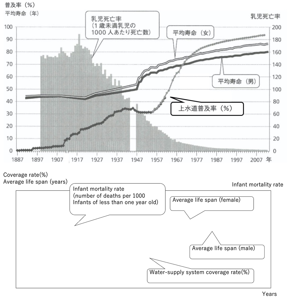
In 1884, a sewerage system (Kanda Sewage) was constructed with guidance from de Rijke, and in 1887 a modern sewerage water supply system was constructed in Yokohama City with guidance from English engineer H.S.Palmer. These technologies spread widely in Japan, and together with the start of chlorine disinfection of drinking water in 1921, infant mortality rate drastically declined (Figure 30).
(Citation: “Suiunshi kara Sekai no Mizue” , p.205)
With respect to hydropower generation, the start was in 1888 at Sankyozawa power generation plant in Miyagi Prefecture for supplying electricity to spinning mill factories. In 1890, the operation of Touma Gendousho started to supply smelting electricity to Ashio Copper Mine. Keage electric power generation plant in Kyoto city, constructed by Sakurou Tanabe in 1891, utilized water from Biwako Sosui. The electricity from this plant was used to start the operation of the streetcar system in Kyoto. Initially hydropower generation systems were small scale, but after the end of Russo-Japanese War (1905) electricity demands for heavy industries and domestic consumption increased rapidly. Large scale concrete gravity dams were constructed, along with long-distance high-voltage transmission systems, for large capacity power generation.
12. River Developments by Constructing Modern Dams (Taisho period (1912-1926) ~ Showa period before the World War II (1926-1939))
Japan’s first dam, Hongouchi Koubu earth dam (H:28m), was constructed for the supply of drinking water in 1889.The country’s first gravity dam, Nunohiki Gohonmatsu Dam (H:33.3m), was built in 1900 in Hyogo Prefecture. The dam was constructed of concrete rubble with the guidance of Englishman William Burton and a design by engineer Toujiro Sato. Since then, for about 30 years up to early Showa Period, concrete dams for drinking water or power generation had been promoted in many parts of Japan concurrently with the establishment of modern industrialization. For agricultural purposes, Honen Ike gravity dam (H=30.4 m, Figure 31) in Kagawa prefecture was initiated in 1926 as a prefecture operated project. Since the base rock was deeper than initially expected, Midori Sugiura, with the guidance of Toujiro Sato, an engineer of the Ministry of Agriculture and Forestry, adopted multiple arch construction methods (rubble mortar masonry), the most advanced technology of the time even in the U.S. With the devotion of Mojiro Kaji, the construction of Honen Ike was completed in 1930 by training technical workers during night sessions and utilizing local embankment materials and 150 thousand man-days of local people. The Japanese Society of Irrigation, Drainage, and Reclamation Engineering was established in 1929.
(Right) Kenchi Ishi masonry filled with rubble mortar
(Citation: Yukikazu Tsuji and others25))
Regarding power generation, tall concrete dams were built using construction techniques like those of today. In 1930, Komaki dam (H=79.2m), Japan’s first concrete dam, was built in Toyama Prefecture. It was followed by Senzu dam(H=64m) in Shizuoka Prefecture in 1935, Tsukahara dam (H=87m) in Miyazaki Prefecture in 1938, and Miura dam (H=84m) in Nagano Prefecture in 1942. Japanese hydro-power generation systems shifted from channel types to water reservoir types during this period.
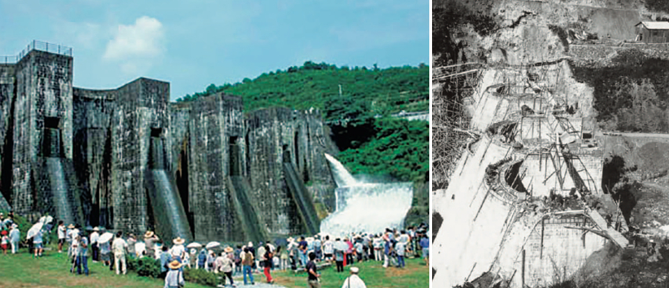
In Heitou Prefecture, the southernmost part of Taiwan under Japanese administration, Nobuhei Torii, an agricultural and rural engineer, constructed Nihou Shyu underground dam in 1921~1923 and converted about 3,000 ha of barren land into sugarcane fields. In Kanan Taishyu, Yoichi Hatta devoted himself to irrigation planning, design, and construction supervision, and completed the construction of Usantou dam (H=56m) after 10 years in 1930. The dam used a semi-hydraulic fill method and was the biggest dam in Asia at that time. It was more than 20 years earlier than Ishibuchi dam (H=53m), Japan’s first rock-fill dam, which was constructed in Iwate Prefecture in 1953. The water scarce Kanan plain became a big grain belt due to Usantou dam. Yoichi Hatta is respected as “the father of Kanan Taishyu” and on May 8th, his death anniversary, local farmers and others even now conduct a memorial service in front of his grave (Figure 32).
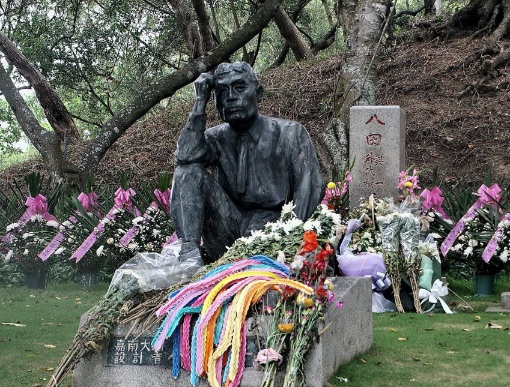
(Photographer: Lienyuan Lee (Shooting date: May 13, 2010))
This picture is licensed under Creative Commons Attribution 3.0 Unported License.
As mentioned, after the late Taisho period, dam constructions started to progress. In this period, urban water demands increased greatly with the progress of defense, heavy-chemical, and machine industries. In addition, intake of agricultural water gradually became difficult due to riverbed declines with the expansion of flood control works and an unclear definition of water rights, which resulted in frequent water use disputes. In 1926, the head of the civil engineering research center, Nagaho Mononobe, proposed river water control projects based on an idea of “transforming flood water into resource”. This proposal was advocated for by the vote of a river subcommittee of a civil engineering council (subcommittee chair: Akira Aoyama) in 1935, and officially became national government policy which then led to the creation of multipurpose dam projects covering flood control and water uses (water for industry, drinking, irrigation, and power generation). Such initiatives were influenced by the Tennessee Valley Authority’s (TVA) comprehensive river development plan established by President Roosevelt to cope with the Great Depression in 1933. River water control projects, initially implemented by prefectural governments with national government subsidy, and dams, including Okiura dam (Asase Ishikawa River), Koudou dam (Nishikigawa River), and Sagami dam (Sagamigawa River), were planned and constructed. Tase dam (Sarugaishigawa River) was the first project directly initiated by the national government in 1942.
After World War II, flood control projects began to be implemented in response to big flood damages, such as Typhoon Kathleen in 1947, and large-scale flood damages have decreased significantly since around 1965. New River Act was enacted in 1964, and river control by consistent management from upstream to downstream with the basin as a unit was introduced. During the Taisho Period and pre-World War II Showa Period, Nagaho Mononobe’s theory was systematically incorporated into legislative systems, and a system of public management of river water was established in Japan.
13. Development of present land improvement technology (Showa Period (1945-1989) after World War II)
In November 1945, the government of Japan gave cabinet approval of Emergency Reclamation Implementation Guidelines to cope with food shortages, with the goal of reclaiming and developing 1.55 million ha. of land within 5 years. Agricultural land reform began in 1946, and the idea of agricultural land ownership turned into owner farmer principle. Land Improvement Act, enacted in 1949, targeted cultivators as principal beneficiaries. Land consolidation associations created under Land Consolidation Act and irrigation associations created under Irrigation Association Act were merged into Land Improvement Districts. After the merger, reclamation projects began to be promoted through Land Improvement Act. In 1950 an invitation was received from the Indian government to join the International Commission on Irrigation and Drainage (ICID), which was under preparation for establishment. After participating as an observer, the Japanese government joined ICID after an approval by the cabinet on Aug.24, 1951. Membership in ICID came before the signing of the San Francisco Peace Treaty in September 1951, and Japan took its first step towards returning to international society through irrigation legislature, even before the restoration of her sovereignty.
After the enactment of the National Comprehensive Development Act in 1950, large scale development projects, including the Aichi Irrigation Project, started in 1957, have been implemented all over Japan using cutting-edge large civil engineering machinery. Support for such moves came from: active mobilization of finances through the borrowing of foreign currency from the World Bank and the use of a special account system, the establishment of organizational frameworks to mobilize special engineers from all over Japan through public corporations and national project offices, and the increase of organizational capacity to functionally respond to problems during project implementation through engineers’ association, universities, research institutes, and private sector. A technological system of irrigation, drainage and reclamation engineering had been established through the completion of mostly technical documents, including a design standard for land improvement projects, in 1954, and revision of an irrigation, drainage and reclamation engineering handbook in 1957 (the first edition was in 1931).
After the high economic growth period of the latter 1950s, the sprawling expansion of urban areas led to water supply confrontations between urban and agricultural use. As a result, the scope of technology in irrigation, drainage and reclamation engineering expanded from addressing just the physical issues of land engineering and water use to integrating regional development technology for dealing with socio-economic situations, including multipurpose water development, redevelopment of suburban areas, and the development of shallow sea area.
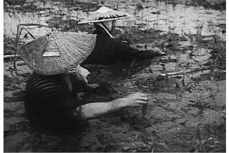
On Niigata plain in those days, lagoons, which were traces of the sea and difficult to judge, lakes, swamps, and rivers were scattered around. Despite the hard work of submerging up to loin or chest in swampy fields (Figure 33), it remained barren land. People would call the area “one cropping in three years”, or “production of Tori Matagi rice (rice even birds don’t eat)”. After 1947, Shinkawa estuary pumping station (Figure 34), one of the world’s biggest, was completed, leading to the implementation of a series of land improvement projects which contributed to transforming the submerged paddy fields’ area into the country’s top grain basket, which in turn resulted in producing many listed companies, including confectionery companies utilizing rice as raw material12).
(Citation: Website of MAFF)
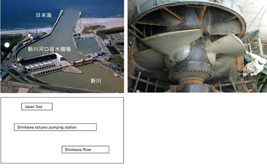
(Right) Main blade of the pump (4,200m:one of the world’s largest)
(Citation: Website of Niigata prefecture)
After 1965 over production of rice became a problem, and the priority of land improvements shifted from land reclamation for paddy fields to improving upland field irrigation systems. The Nansatsu project (Kagoshima prefecture) (Figure 35) transformed the rough barren land of Shirasu or Kora volcanic soil to one of the largest agricultural production areas through a large scale upland irrigation system incorporating a natural lake (Ikeda lake) as a regulating reservoir.
During the same period, computer processing technology has been applied for collecting information through either wire or wireless communication systems, and from the early 1970s remote control systems have been introduced for information collection. After the Okinawa islands were returned to Japan in 1972, an underground water development study was initiated on Miyako island of Okinawa prefecture, and with the efforts of agriculture and forestry engineer Mutsuo Kurokawa and others, Minafuku underground dam was completed in 1979. Through practical experiments carried out at Minafuku underground dam, underground dam technology was systematized, and water scarce elevated coral reef islands in the Nansei Islands started to be developed by underground dams.
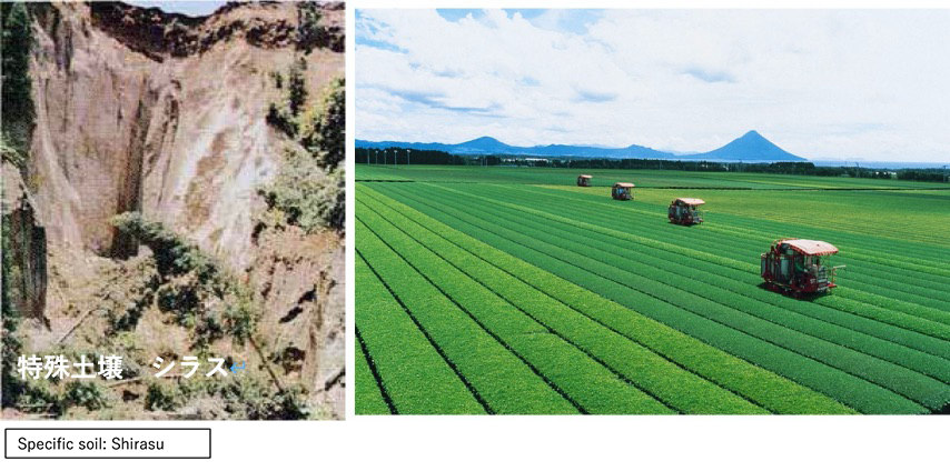
Poor volcanic ash soil of Shirasu or Kora became a leading production base of tea, okra, and broad beans through irrigation system development and land consolidation (provided by: Agriculture policy department of Kagoshima Prefecture (left), Minami Kyushu City (right))
14. System renovation and measures against regional issues (Heisei period (1989-2019))
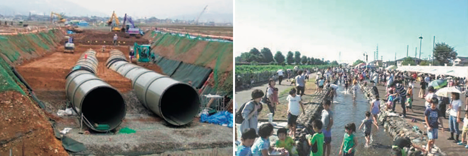
During the period of Heisei, rural structure and water use environments surrounding agriculture have changed significantly, mainly due to the aging of rural populations, urbanization, mixed rural/urban living, emergence of large scale farmers by retirement of individuals from farming, and accumulation of farming lands. New water resource development became difficult, and efficient use of developed water resources was requested. New projects were established including the National Agricultural Water Reorganization Project, the Promotion of Regional Water Function Project, and the Conservation and Consolidation of Natural Environments Project. Furthermore, small hydraulic power generation systems have been introduced in water use facilities. In the Food, Agriculture, and Rural Areas Basic Act, enacted in 1999, articles concerning multifunctional roles of agriculture and consideration of the environment were added to the Land Improvement Act. In downstream areas of the Kuzuryugawa River in Fukui Prefecture, consolidation of farmlands progressed, but problems started to emerge, including degrading of its water course, decrease of paddy field areas by production adjustment and farmland conversion, and water scarcity due to salt damage. Thus, local water use assets were reorganized by pipelining the main canal by National Project in 1999, and the agricultural water reorganization project started to reallocate surplus water to surrounding areas, and promoted regional water uses by utilizing old water courses, such as the “Seseragi water course” for fire prevention, and domestic water and landscape improvement (Figure 36).
At this time, irrigation facilities that had been developed during the post war period for food production began to require renovation and the focus of projects shifted from new construction to renovation and repairs. For 5 years from 2007, all national government developed facilities’ functions were evaluated to develop and consolidate stock management related technology standards. In 2011 a project support system concerned with preserving and maintaining functions of irrigation and drainage facilities was established during a significant reduction of land improvement project budgets that began in 2010. After the Great East Japan Earthquake on March 11, 2011, disasters, including large scale earthquakes or torrential rain have occurred in many parts of Japan. The Fundamental Plan for National Resilience was adopted in 2018.
In 2015 a basic plan for food, agriculture and rural areas specified the promotion of ICT technology and underground water control systems to lessen human labor in water management and to achieve water use sophistication in accordance with changes in farming systems. This plan was created to cope with variations in irrigation periods, irrigation demands, and water management caused by aging farmers and progress in land consolidation/intensification.
15. Conclusion
Agricultural and rural engineering, that may also be called the origin of water technology in Japan, developed and spread in accordance with specific local conditions through the devotion and innovation of many engineers, who based their technology on what was transmitted from continental Asia and spread during the ancient period. Such cycles of transmission, spread and development have been repeated. Water courses have not only been used for irrigation, but also for transport and drinking water. Water wheels became a source of energy, which led to the creation of a recycle oriented society in the early modern times. During the modern period, embankment technology originating in constructing ancient tombs and ponds has been synthesized into a highly sophisticated dam technology, which is used for industrial and urban water supply, flood regulation, hydropower generation, and support for industries of a technology-driven nation. As of now, in response to social demands, agricultural and rural engineering have expanded the technology’s scope from civil engineering oriented fields, such as geotechnical engineering, structural engineering, and concrete engineering, to a comprehensive technology of regional total coordination, fully utilizing the knowledge of facility machinery, telecommunication, hydrometeorology, farming, environment and legislation system.
In the field of agricultural and rural engineering, standardization of design has been promoted through the rapid development of standard books, technical documents, and the wide application of computers works, which have significantly improved the efficiency of the technology. In order to pass various screening committees for construction order and on-site inspection by the board of audit after implementation, designs based on manuals are most uncontroversial, while additional labor for accountability and risks are involved if innovative technology should be applied. In our present society where information rapidly advances and the mass production age has already been terminated, engineers should not always depend too much on uniform standards and previous examples but act on essential problems that meet the specific needs of on-site conditions and end users by applying appropriate technology. To that end, labor productivity needs to be improved by enhancing the efficiency of works involved by constant improvements without always following conventional practices. Incidentally, the often cited “resource poor country” of Japan has advanced technology, human resources with a cooperative personality, and rich ocean energy and mineral resources at the bottom of the sea in the world’s 6th largest Exclusive Economic Zone13). When technical difficulties are cleared, Japan will be able to self-supply energy and resources stably.
This chapter on water concludes with a message posted in a land improvement district office for water engineers of the present age, the “Mizu Go Soku (five water.)” *
- 1. It is water that always seeks its own direction and moves others by moving itself.
- 2. It is water that has compatible characteristics that overcome any obstacle and accumulate enough force to break through a rock, but also conforms to the shape of its container.
- 3. It is water that makes others clean by its own purity and tolerates cleanness and dirtiness altogether.
- 4. It is water that offers unlimited services to production and livelihood through force and light without seeking rewards.
- 5. It is water that fills boundless oceans, evaporates into clouds and rain, changes into snow or hail, and freezes into a glorious mirror, but still maintains its essential characteristics.
*It originated in Chinese classics and was the motto of Jyosui (Kanbei) Kuroda, the founder of Fukuoka domain, and Ryoichi Sasakawa. Some called it the “Mizu Go Kun (five water lessons)” or “Mizu Roku Kun (six water lessons)”.
Citations
1. Website of Dambinran.
https://www.damnet.or.jp/Dambinran/binran/TopIndex.htm
2. Project Team of Obayashi Gumi Construction Company. “Construction of Emperor Nintoku Tomb by Modern and Ancient Technologies”. Website of Obayashi Gumi.
https://www.obayashi.co.jp/kikan_obayashi/detail/kikan_20_idea.html
3. Shigeki Matsuura. Kodai Bonchi niokeru Kaihatu to Kasensyori (“Developments and River Treatments in Ancient Valley”). Water Science, Vol.2. No. 271983.
4. Fujio Yamazaki. Suiden Monogatari (“Stories of Paddy Fields in Japan”). Rural Culture Association Japan, 1996.
5. Website of Ogura-ike National Land Disaster Prevention Project.
https://www.maff.go.jp/kinki/seibi/sekei/kokuei/oguraike/oguraike05.html
6. Website of Asakura City, Fukuoka Prefecture.
https://www.city.asakura.lg.jp/www/index.html
7. Nihonga Hokoru Sekai Kangai Shisetu Isan (“World Irrigation Heritage Sites in Japan”). Toho Press, 2019.
8. Mitsukan Water Culture Center. Journal of Mizu no Bunka (”Water Culture”).
No.32, 2009. https://www.mizu.gr.jp/archives/32_midaigawa2.html
9. Kenichi Tanigawa. Kato Kiyomasa – Chikujyo to Chisui (“Kato Kiyomasa – Castle Construction and Flood Control”). Fuzambo International Company, 2006.
10. Website of Ministry of Land, Infrastructure and Transport, Sewage Department, Sewage Document Office.
https://www.mlit.go.jp/mizukokudo/sewerage/crd_sewerage_tk_000008.html
11. Website of Usa City, Oita Prefecture.
https://www.city.usa.oita.jp/index.html.
12. Monthly Journal Colombus. Toho Press. April, 2019.
13. Website of Agency for Natural Resources and Energy.
https://www.enecho.meti.go.jp/
References
1. Akira Takubo. Suiden to Zenpou Kouenfun. (Paddy Fields and Keyhole-shaped Tomb”). Nobunkyo Production, 2018.
2. Koichi Yamamoto. Nippon no Suisei (“Water System in Japan”). Sankaido Co.Ltd., 1996.
3. Kazuko Toyama. Mizuno Bunkashi (“Cultural History of Water”). Chyuo Koron Shinsha, 2013.
4. Nogyodoboku Rekishi Kenkyukai. Daichi heno Kokuin (“Heritage of Land Development”), 1998.
5. Crowns Prince Naruhito. Suiunshi kara Sekai no Mizue (From History of Water Transport to World Water”). NHK Publishing Co., 2019.
6. Kasen Riyou no Rekishi (“History of River Uses”). National Land and Transport Ministry.
7. Ryozo Matsuyama. Nihon no Nougyoshi (“Agricultural History of Japan”). Shinpu Sha, 2004.
8. Professor Takehide Hama, Kumamoto University. Presentation material of Exchange Meeting of Kataribe. 28, Nov., 2019.
9. Website of Ministry of Land, Infrastructure and Transport. Mizuriyou no Rekishi (“History of Water Use”).
https://www.mlit.go.jp/mizukokudo/mizsei/mizukokudo_mizsei_tk2_000013.html.
10. 100-Year History of Land Improvements. Heibon Publishing Co. 1977.
11. Toshio Kikuchi. Shinden Kaihatsu (New Paddy Fields Developments”). Shibundo, 1963.
12. Association of Irrigation, Drainage and Reclamation Engineering. Nogyo Dobokushi (“History of Irrigation, Drainage and Reclamation Engineering”). 1979.
13. Yukikazu Tsuji and Teruo Miyazaki. Hachijyunen woheta Maruchipuru Aachi Konkuriito Damu no Honenike no Kenzo to Kaishyu (“Construction and Renovation of Multiple Arch Concrete Dam, Honen Ike Pond after 80 years”). Concrete Journal. Vol. 29, No. 4, p.52-57, 2011.
14. Shigeki Matsuura. Senzen no Kasui Tousei Jigyo to sono Shakaiteki Haikei (“River Water Control Projects of Pre-war Period and its Social Bakcgrounds”). Papers of the Research Meeting on the Civil Engineering History in Japan, p.187-195, June, 1985.
15. Tokuhisa Matsumoto. Wagakuni Firu Damu no Sekkei Sekou no Hensen (“Transition of Desing and Construction of Fill Dams in Japan”). Doboku Gakkai Ronbunshuu F, Vol.65, No.4, p.394-413, 2009.
16. Tadayuki Maeshiro. Miyakojima no Mirai to Chikadamu Kouroushatachi (“Future of Miyako Island and Meritorious Persons”). Shimatati, No. 64, p.40-43, 2013.
17. Junya Hanada. Miyakojima ni okeru Nougyou Yousui Kaihatu no Rekishi to Nougyou Suiri Sisetu no Keisho (“The Development and Inheritance of Agricultural Water Facilities in Miyako-Jima Island). Journal of Water, Land and Environmental Engineering, Vol. 82, No.11, 2014.
18. Nihonga Hokoru Sekai Kangai Shisetu Isan (“World Irrigation Heritage Sites in Japan”). Toho Press, 2019.